Building Surveys (BIM)
Building Information Modelling (BIM) is a digital process that creates and manages data during the design, construction, and operations process. BIM provides a three-dimensional (3D) virtual model of a structure, enriched with data and information. This allows multiple stakeholders to work together on a shared platform, improving communication, collaboration, and decision-making.
We work closely with Architects to do As-Built Surveys of Existing Buildings for Upgrades and Extensions. We regularly use 3D Laser Scanning (LIDAR) for Building Information Modelling (BIM) and have fine-tuned workflows for producing 3D Models, Plans, Elevations, and Sections of Existing Buildings.
We also do Topographic Surveys to produce Contour Plans and 3D Digital Terrain Models for the Design Phase and CNC/3D Printing of Scale Models. Additionally, we offer Stake-out and Positioning services during the Construction Phase to ensure everything is built in the right place and within Design Specifications.
Building Surveys
3D Scanning for BIM
3D Terrain Models
Scale Plans
Building Surveys (BIM)
Building Information Modelling (BIM) is a digital process that creates and manages data during the design, construction, and operations process. BIM provides a three-dimensional (3D) virtual model of a structure, enriched with data and information. This allows multiple stakeholders to work together on a shared platform, improving communication, collaboration, and decision-making.
We work closely with Architects to do As-Built Surveys of Existing Buildings for Upgrades and Extensions. We regularly use 3D Laser Scanning (LIDAR) for Building Information Modelling (BIM) and have fine-tuned workflows for producing 3D Models, Plans, Elevations, and Sections of Existing Buildings.
We also do Topographic Surveys to produce Contour Plans and 3D Digital Terrain Models for the Design Phase and CNC/3D Printing of Scale Models. Additionally, we offer Stake-out and Positioning services during the Construction Phase to ensure everything is built in the right place and within Design Specifications.
Building Surveys
3D Scanning for BIM
Scale Plans
3D Terrain Models
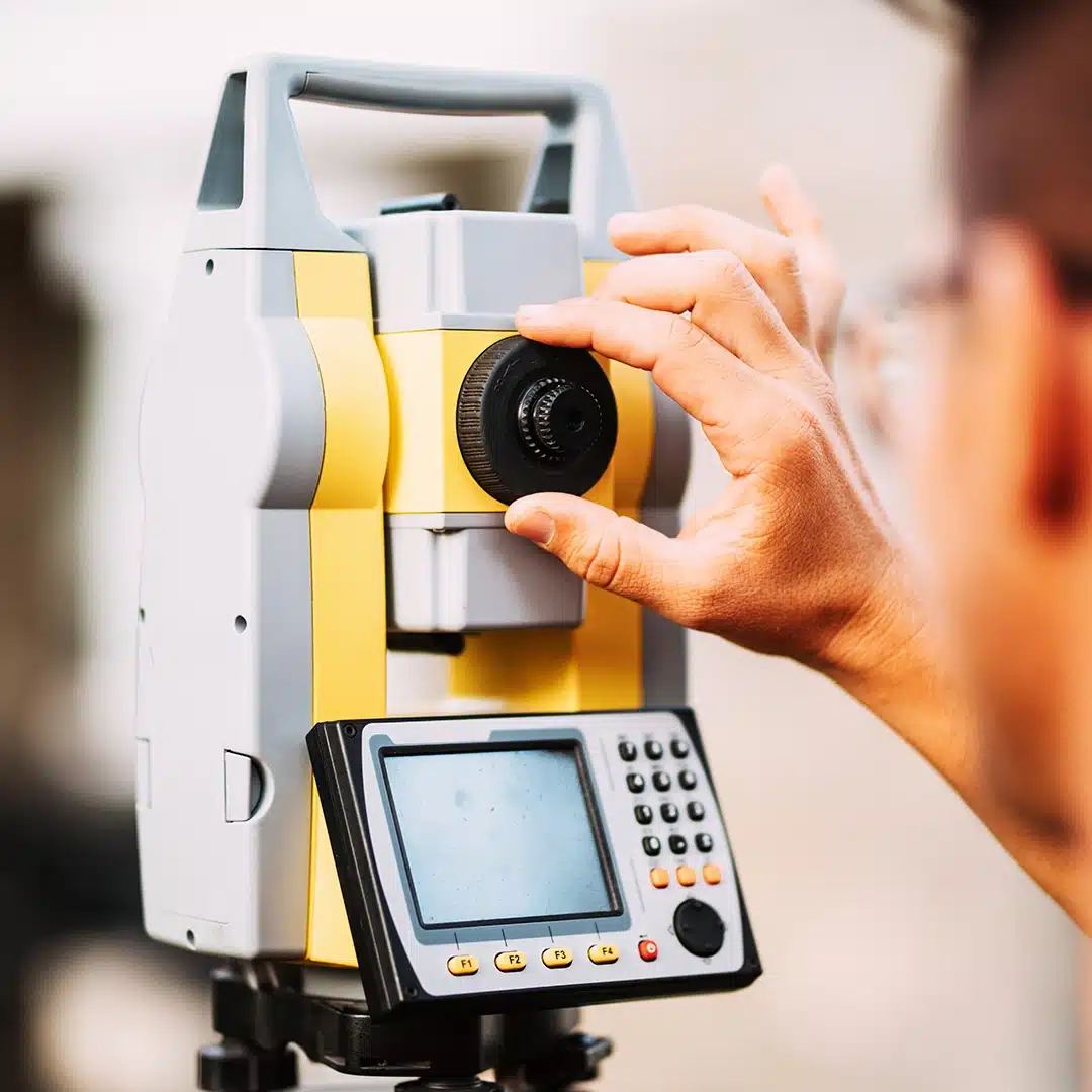
As-Built Surveys and Laser Scanning
Our experience in surveying buildings and construction dates back to 2001, and we have been developing and streamlining our workflows ever since. We employ staff who are experienced in combining multiple survey techniques, including 3D Laser Scanning (LIDAR), to survey a building cost-effectively and efficiently. Laser Scanning (LIDAR) is a very powerful tool that represents buildings in 3D. Plans, Sections, Elevations, 3D Revit Models, BIM, etc., can be created from Point Cloud. One of the main advantages of Laser Scanning is that it captures everything visible from the scanner, and we have the option to periodically extract more and more information from the point cloud without having to go back to site.
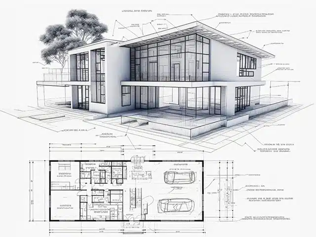
Plans, Elevations, and Sections
While 3D products are becoming increasingly popular, 2D plans, sections, and elevations remain essential for building construction. We produce neat, easy-to-read scale plans with distinct line types, descriptive layer names, and clear height annotations that can be used electronically or printed out and walked on-site. Our plans can be issued in a generic CAD format that works on many software packages or as extracts from 3D Revit models for clients interested in BIM. We understand the importance of clear and accurate 2D drawings and work closely with our clients to ensure their needs are met. We pride ourselves on our attention to detail and our commitment to providing high-quality work.
As-Built Surveys and Laser Scanning
Our experience in surveying buildings and construction dates back to 2001, and we have been developing and streamlining our workflows ever since. We employ staff who are experienced in combining multiple survey techniques, including 3D Laser Scanning (LIDAR), to survey a building cost-effectively and efficiently. Laser Scanning (LIDAR) is a very powerful tool that represents buildings in 3D. Plans, Sections, Elevations, 3D Revit Models, BIM, etc., can be created from Point Cloud. One of the main advantages of Laser Scanning is that it captures everything visible from the scanner, and we have the option to periodically extract more and more information from the point cloud without having to go back to site.
Plans, Elevations, and Sections
While 3D products are becoming increasingly popular, 2D plans, sections, and elevations remain essential for building construction. We produce neat, easy-to-read scale plans with distinct line types, descriptive layer names, and clear height annotations that can be used electronically or printed out and walked on-site. Our plans can be issued in a generic CAD format that works on many software packages or as extracts from 3D Revit models for clients interested in BIM. We understand the importance of clear and accurate 2D drawings and work closely with our clients to ensure their needs are met. We pride ourselves on our attention to detail and our commitment to providing high-quality work.
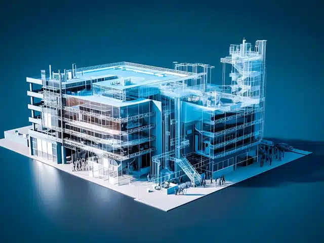
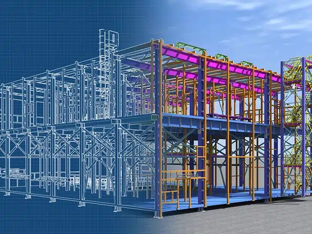
3D Building Modelling (BIM)
Our survey services include 3D As-Built Models of Buildings in various formats like BIM Models in Revit, 3D Solid Models in generic CAD Packages like AutoCAD and Sketchup, etc. 3D Building Models help clarify Complex 3D Spatial Relationships in Buildings that need to be modified or upgraded and introduce a level of understanding that cannot be obtained from 2D plans. These services are used, not only by Architects, but Property Managers, Developers, Structural Engineers, etc. for whom they are also valuable. We enjoy creating fully rendered 3D Models from Design Plans for presentation purposes and also provide options for 3D Printing of Real-life Life Scale Models.
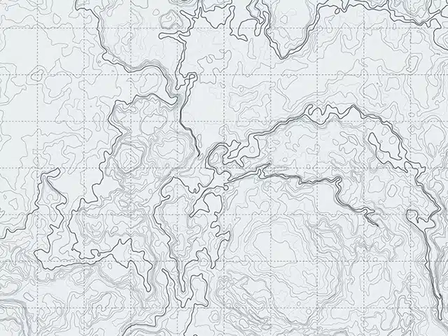
Contour Plans and Terrain Models
We regularly survey ground surfaces, both natural and man-made, and we offer services from conventional Survey to Laser Scanning. While there are a multitude of different ways to represent the data, typical formats include Topographic Maps with Contours, Cross-Sectional Profiles, Triangulated Irregular Networks (TIN), Digital Terrain Models (DTM), and Point Clouds (LIDAR), etc. We can run analysis tools from these models to calculate Volumes of Stockpiles, simulate the Flow of Water, etc. We offer various Services, Equipment, and Techniques and always comply with Safety Regulations in hazardous areas like Mines and Construction Sites. Our compliance ensures safety at every step.
3D Building Modelling (BIM)
Our survey services include 3D As-Built Models of Buildings in various formats like BIM Models in Revit, 3D Solid Models in generic CAD Packages like AutoCAD and Sketchup, etc. 3D Building Models help clarify Complex 3D Spatial Relationships in Buildings that need to be modified or upgraded and introduce a level of understanding that cannot be obtained from 2D plans. These services are used, not only by Architects, but Property Managers, Developers, Structural Engineers, etc. for whom they are also valuable. We enjoy creating fully rendered 3D Models from Design Plans for presentation purposes and also provide options for 3D Printing of Real-life Life Scale Models.
Contour Plans and Terrain Models
We regularly survey ground surfaces, both natural and man-made, and we offer services from conventional Survey to Laser Scanning. While there are a multitude of different ways to represent the data, typical formats include Topographic Maps with Contours, Cross-Sectional Profiles, Triangulated Irregular Networks (TIN), Digital Terrain Models (DTM), and Point Clouds (LIDAR), etc. We can run analysis tools from these models to calculate Volumes of Stockpiles, simulate the Flow of Water, etc. We offer various Services, Equipment, and Techniques and always comply with Safety Regulations in hazardous areas like Mines and Construction Sites. Our compliance ensures safety at every step.